Following US airstrikes on Iran’s crucial oil export island, Kharg, Donald Trump claimed that “every MILITARY target” had been “totally obliterated”. Yet the few pieces of publicly available information paint a contradictory picture. A geolocation of footage released by the US military suggests that several strikes may have hit civilian infrastructure. Based on an open source intelligence (OSINT) analysis, etos.media editor Jakob Reimann explains what can be reconstructed about the targets of the attacks.
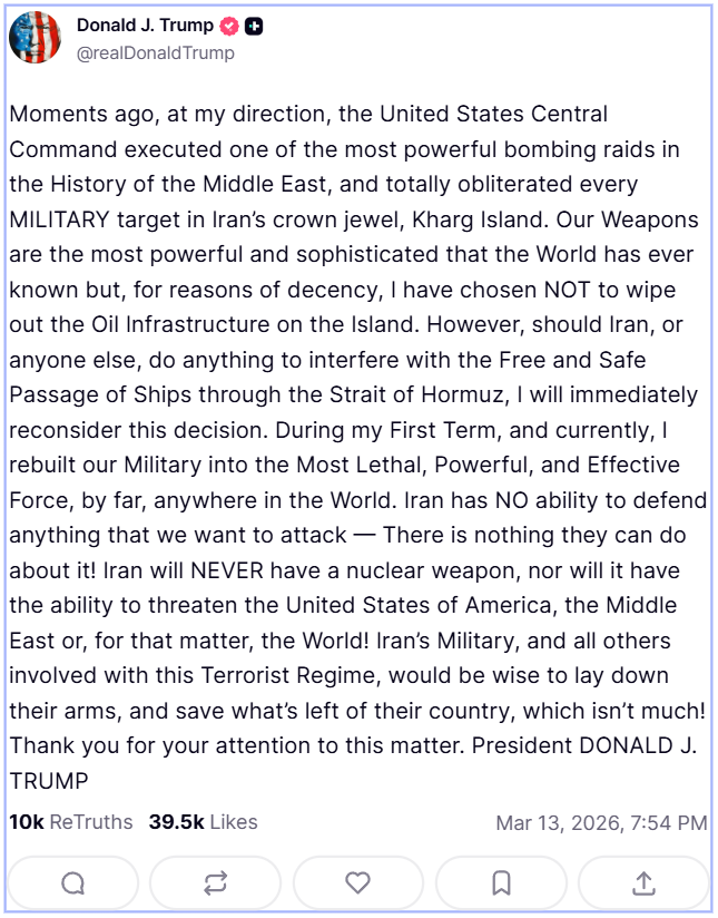
“Moments ago, at my direction, the United States Central Command executed one of the most powerful bombing raids in the History of the Middle East,” the US president wrote on Friday in a post on his social network Truth Social, “and totally obliterated every MILITARY target in Iran’s crown jewel.” Trump continued: “for reasons of decency, I have chosen NOT to wipe out the Oil Infrastructure on the Island.”
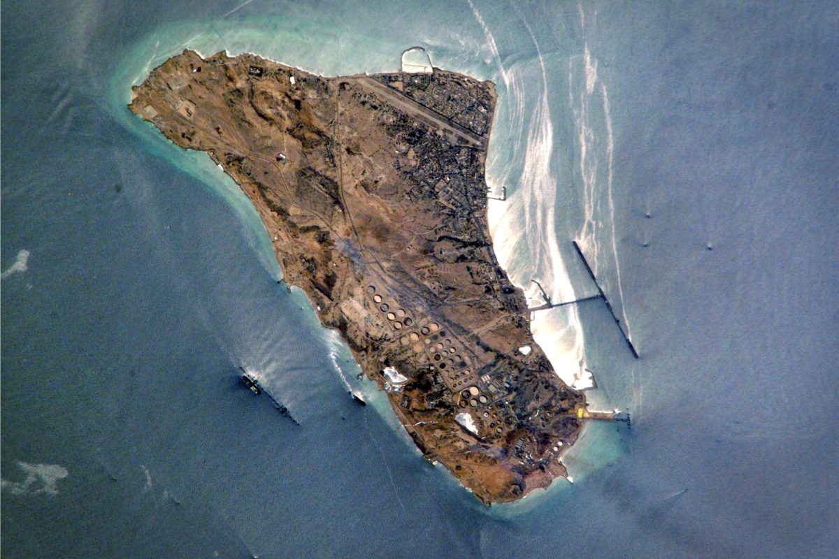
The island, covering around 20 square kilometers—smaller than Manhattan—lies in the northern part of the Persian Gulf, around 60 kilometers from the Iranian port of Bushehr. It is widely regarded as the “undisputed economic backbone of Iran”: around 90 percent of the country’s crude oil exports are handled from here, amounting to nearly one billion barrels per year.
So far, it remains largely unclear which targets were actually bombed in the overnight attacks on early Saturday. According to the US president, “every MILITARY target” was destroyed, while Reuters, citing the US CENTCOM, reported that 90 military targets had been attacked. By contrast, the Iranian agency Fars, citing sources on the ground, reported that “the sound of more than 15 explosions was heard on the island” and that “the enemy attempted to damage the army’s air defense system, the Joshan naval base, the airport control tower, and the helicopter hangar of the [Iranian Offshore Oil Company].” Two military and two civilian targets were named, though it remains unclear what the outcome of these “attempts” actually was.
“The airport is right in the middle of the city, and practically everything is within residential areas,” one resident of Kharg city told BBC Persia. “Almost all of Kharg Island’s military facilities are located around the airport, and the rest are oil and gas installations and the accommodation of oil company employees,” said another. “The island doesn’t really have a military base as such, and I truly don’t know what they actually hit.”
US CENTCOM—the US military’s regional command in charge of operations in the area from East Africa to Central Asia—has released a compilation of several video sequences that allegedly show strikes on the island.
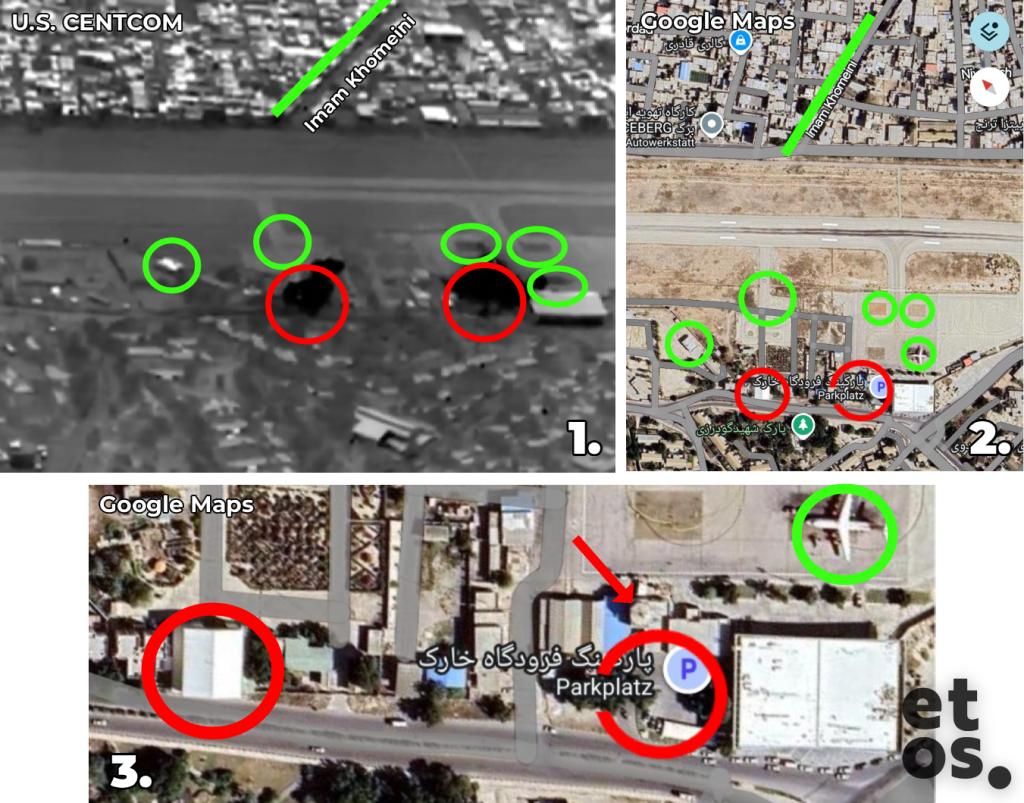
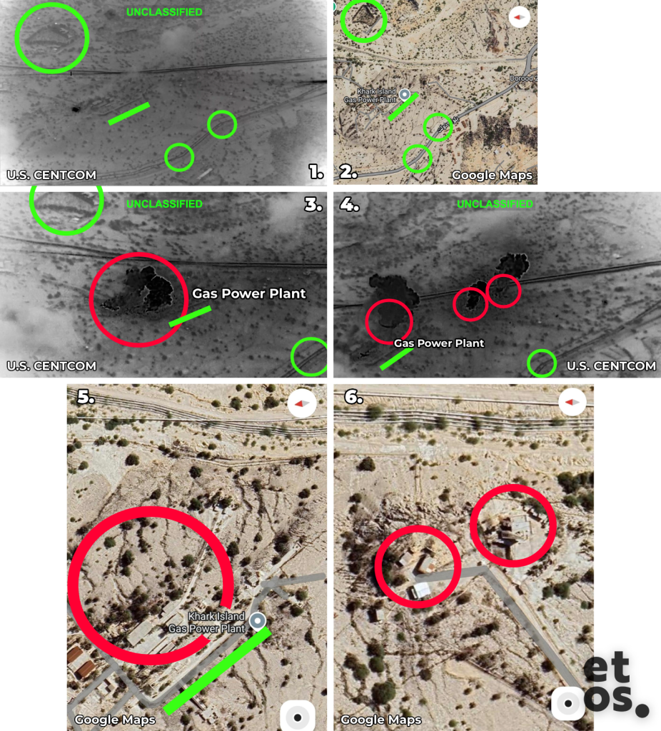
By comparing distinctive building shapes, road layouts, and terrain features with satellite imagery from Google Maps, etos.media was able to geolocate the impacts. (In the following graphics, green elements mark reference points used for geolocation, while red elements indicate the projectile impacts.)
Two video sequences show impacts at Kharg Airport. The first clip shows a projectile striking a parking lot (according to Google Maps) next to a large building and several smaller ones. One of the buildings has a kind of hexagonal top (red arrow). Another projectile hit a larger hall located about 60 meters southwest of five helicopter landing pads. The analysis of the footage suggests that the two targeted structures are the airport control tower and the helicopter hangar of the Iranian Offshore Oil Company, as mentioned by the Iranian agency Fars. Both strikes would constitute attacks on civilian or civilian-used infrastructure.
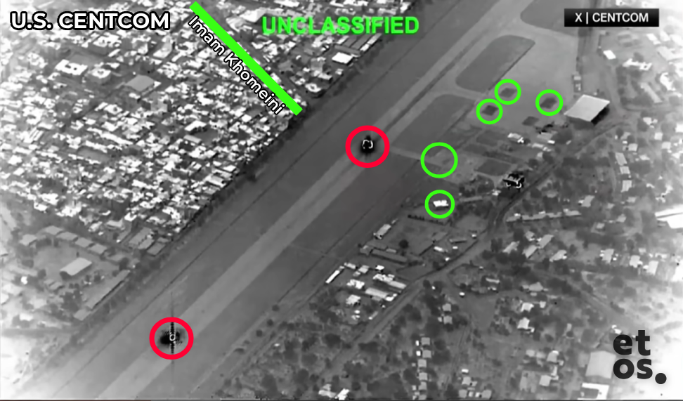
Another sequence shows two impacts on the airport’s airfield: one roughly at the level of the oil company’s helicopter hangar, the second about 650 meters northwest of it. Here too, the strikes would have hit civilian infrastructure.
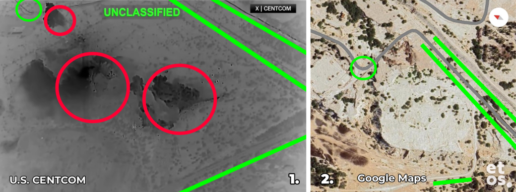
The next sequence shows some kind of barren limestone plateau in the northern part of the island. Even at the highest zoom level on Google Maps, no buildings or other structures can be identified at the impact locations.
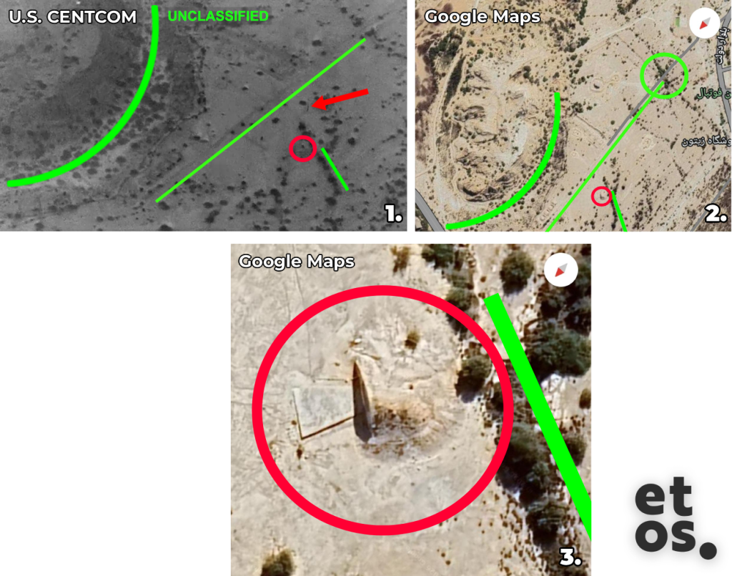
The next excerpt ends immediately after the impact, so the smoke plume in the landscape is not visible. However, the red arrow marks the projectile just before impact (clearly visible in the video), while the red circle marks the impact site in a barren area in the northwest of the island. It is unclear what structure this might be. The shape of the building resembles a hangar. However, this appears unlikely, as no other infrastructure is visible in the surrounding area and no paved road leads to the site—factors that argue against it being a military structure.
Another sequence shows multiple impacts in the northern central part of the island. The two smaller explosions occurred near an oil pipeline. Several buildings were apparently struck, which could be storage warehouses and part of an industrial facility. The larger detonation occurred on a site that, according to Google Maps, hosts the island’s gas power plant. This facility supplies electricity for the island itself. If the power plant was indeed bombed, this would constitute an attack on energy infrastructure essential for civilian supply.
The OSINT analysis of the video sequences released by the US military raises significant doubts about the US president’s account. In the clips examined, etos.media was unable to identify clear military targets. Several strikes appear to have hit civilian infrastructure such as the gas power plant, the airport tower, the helicopter hangar, and possibly industrial facilities. In a Saturday interview with Kristen Welker on NBC, Trump threatened further strikes on the island—“just for fun”.
This is a translation of an article that originally appeared in German at etos.media.